Around 1900, Jerusalem is the seat of the Mutasarrifate of Jerusalem, a special Ottoman province created in 1872 and answering directly to Constantinople rather than to a regional governor. Besides the city itself, it administers Hebron, Jaffa, Gaza and Beersheba. The city is also outgrowing its own shape: between 1881 and 1897, the share of its population living outside the walls climbs from 6 per cent to nearly half, carried by new neighbourhoods and by the European consulates that had begun settling there in the 1840s. The photochroms we print from Jerusalem, made between 1890 and 1900 by Photoglob Zürich and the Detroit Photographic Co., read this double city through three entries: the gate you pass through, the height you view it from, and the trade you meet in its street.
Through the Jaffa Gate
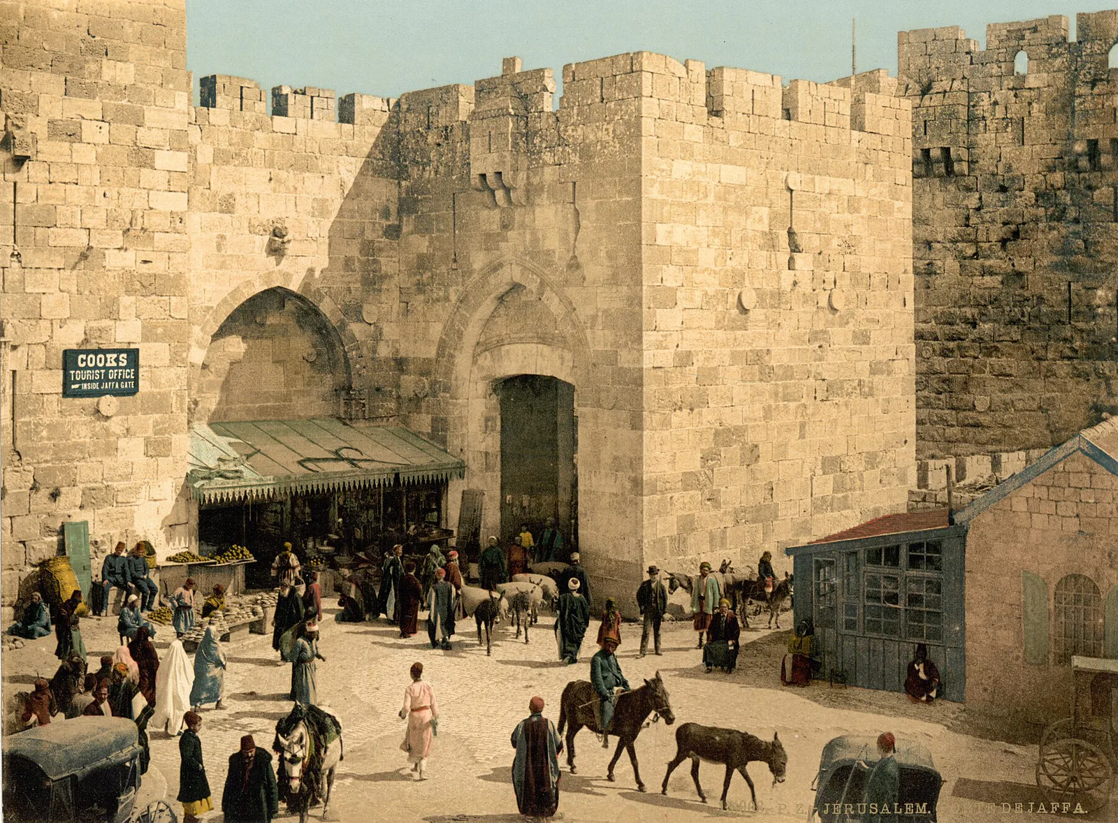
A traveller landing at the port of Jaffa reaches Jerusalem through a single gate, cut into the west wall in 1538 under Suleiman the Magnificent: the Jaffa Gate, باب الخليل — "Gate of the Friend," meaning Hebron, where Abraham is said to rest. The roads to Jaffa and to Hebron both start here, and around 1900 it draws more caravan, merchant and pilgrim traffic than the Damascus Gate does — enough that a clock was mounted on it in 1907, and an ornate tower raised the following year to carry it, marking twenty-five years of Sultan Abdülhamid II's reign. Our plates predate it: the gate they show doesn't have its tower yet. It no longer has one either — the British tore it down in 1922.
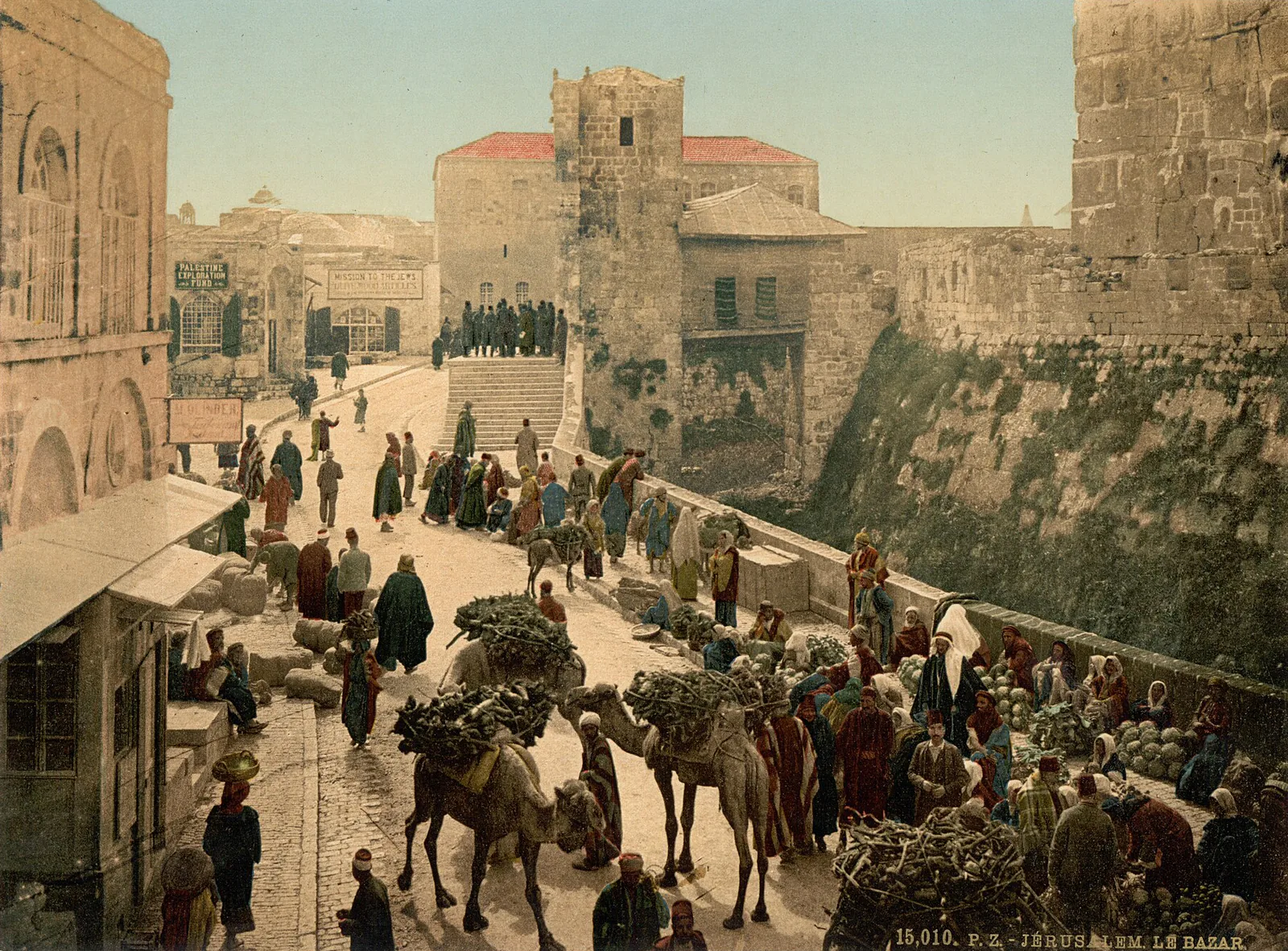
Ten steps into the city and the street already opens into a market: in the plate of the Bazaar by the Tower of David, two camels loaded with bundles of brushwood pick their way along the rampart, past vegetable stalls and merchants sitting on the bare ground — what a traveller meets first, before choosing a direction into the city at all.
Three more gates, one campaign
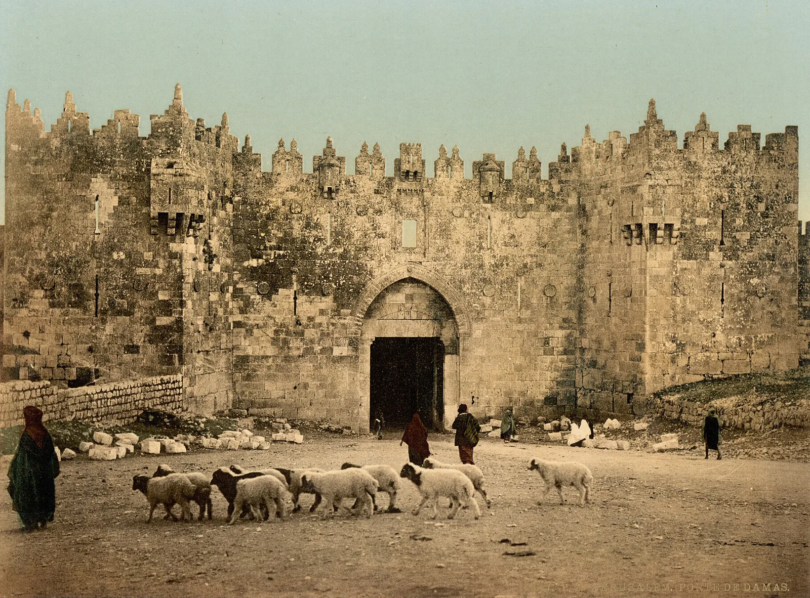
Three further gates round out our collection, and all date from the same fortification campaign, carried out under Suleiman between 1537 and 1541. To the north, the Damascus Gate, باب العامود, "Gate of the Column," has carried that name since at least the tenth century, recalling a Roman column once raised on the square behind it; it opens the road to Damascus and sees caravans and pilgrims pass through. In our plate, a flock of about ten sheep crosses the open ground before the gate, driven by women in dark cloaks; cut stone blocks, not yet set in place, still litter the ground at the foot of the rampart. The Crusaders already knew this gate as Porta Sancti Stephani, St Stephen's Gate.
That name has since moved: it now belongs to St Stephen's Gate, باب الأسباط, which opens east, on the far side of the city, where the Via Dolorosa begins for Christian pilgrims, and which English-speaking visitors know better as the Lions' Gate. The last of the four, the Golden Gate, باب الرحمة, "Gate of Mercy," cannot be crossed at all: sealed in 810, reopened by the Crusaders in 1102, walled up again after 1187, it was sealed a final time by Suleiman in 1541. It faces the Mount of Olives and appears in no photograph except from outside — a threshold to look at rather than pass through, and it has stayed that way.
The view from above
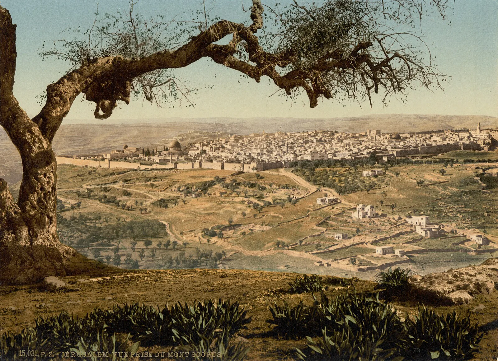
Two plates show no gate at all: they look at the whole city from a height. The general view is taken from the Mount of Olives, to the east, from which the walls, the domes and the esplanade line up in a single frame.
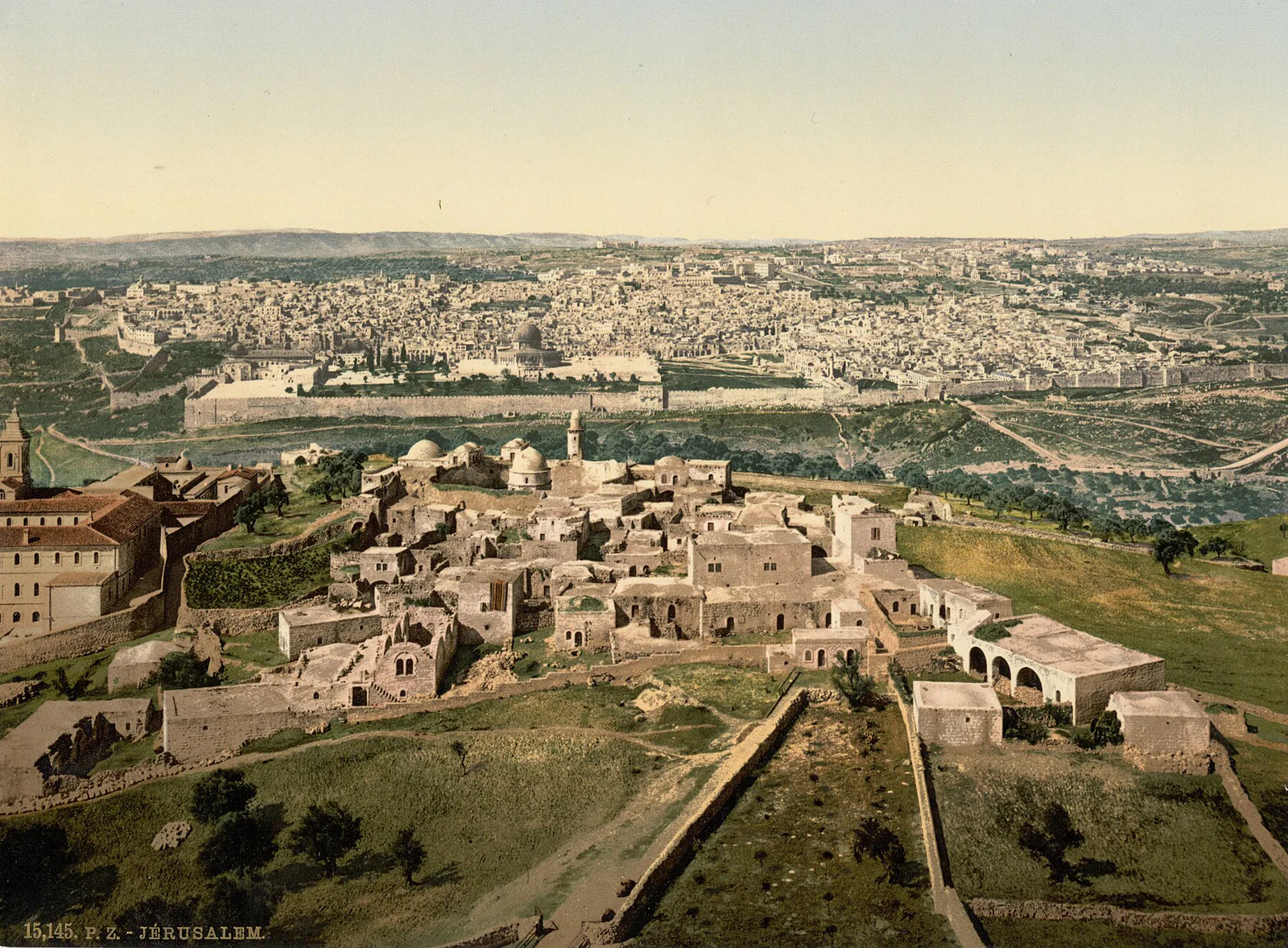
The other is taken from Mount Scopus, which overlooks the city at 826 metres to the northeast. Its very name gives away its purpose: Har HaTsofim in Hebrew, Jabal al-Mashārif (جبل المشارف) in Arabic, Scopus in Greek — three languages, and all three call it a watching place, an older use than the 1900 traveller's own: Roman legions camped there during the siege of the year 70, and Crusaders pitched their tents there in 1099. Around 1900 it is still the same lookout that every traveller climbs to photograph the city rather than to linger; the Hebrew University would not open there until after the First World War.
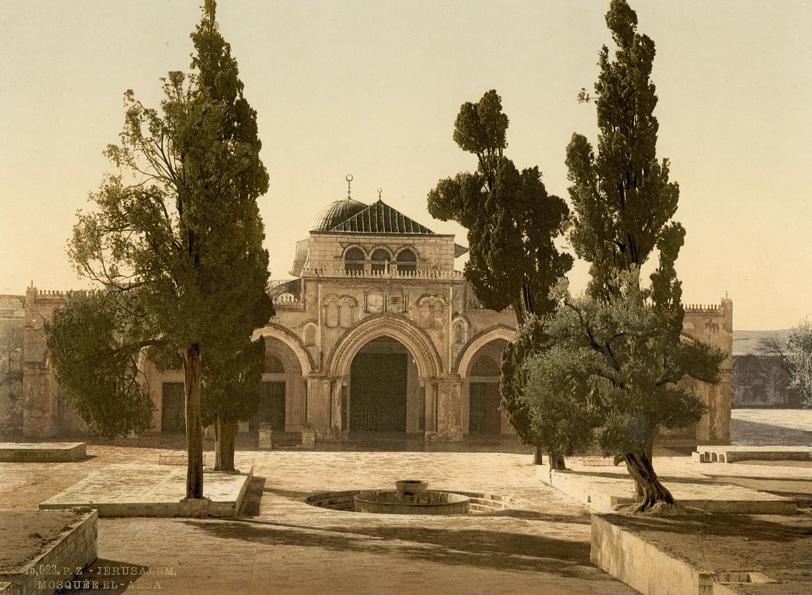
What these two heights show at a distance, a third plate closes in on: the Al-Aqsa Mosque, a building distinct from the Dome of the Rock, raised in the seventh or eighth century by the Umayyad caliphs and later restored under the Abbasids and then the Fatimids, standing at the southern end of the esplanade that Arabic calls the Haram al-Sharif, "the Noble Sanctuary," and that Hebrew calls Har HaBeit, the Temple Mount. The photographer frames it by its architecture and nothing else.
A city without a network
Since antiquity, a system of aqueducts has linked Jerusalem to the springs that feed Solomon's Pools, near Bethlehem; maintained and renewed, it would go on supplying the city until 1967. It's a year or two after our plates were made, in 1902, that the Ottoman administration opens a sixteen-kilometre pipeline from those same springs, to mark Sultan Abdülhamid II's sixtieth birthday — the first step toward a pressurised water supply. What that step was meant to correct, our own collection shows by implication: the Swiss publisher had, in those same years, a plate of a water carrier bearing his load on his own back in its catalogue — a sight common enough, at the time, to earn its place there.
Four plates record what a street without piped water looked like. The Water Carrier carries a whole goatskin waterskin on his back, held by a strap and by his own hand. The Itinerant Cobbler mends shoes sitting on the bare ground against a wall, his tools set out in a metal basin in front of him. In Peasant Women at the Millstone, three women sit around a stone quern, sorting and grinding wheat by hand. The Bread Sellers stack their flatbreads in front of a dark, vaulted niche, cut straight into the wall behind them. None of these four scenes needs an enclosed workshop or a machine: together they describe a street economy on the eve of a pipeline that would change it.
Three entries, one city
What these three entries show together is a single Ottoman city, caught between its walls and its outlying districts, a few years short of the water network it doesn't yet have. On the process that fixed these colours, our article on the photochrom goes into more detail.
Sources
- Moutassarifat de Jérusalem — Wikipédia
- Jerusalem's Bright Future at the Turn of the 20th Century — Jerusalem Story
- Porte de Jaffa — Wikipédia
- Jaffa Gate — Wikipedia (English)
- Damascus Gate — Wikipedia
- Golden Gate (Jerusalem) — Wikipedia
- General view, Jerusalem, Holy Land — Wikimedia Commons
- Mount Scopus — Wikipedia
- Al-Aqsa Mosque — Wikipedia
- Solomon's Pools — Wikipedia
- Lions' Gate — Wikipedia